
Business Details
25 Years
experience
Expert Land Surveying Services in Geraldton, WA
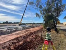
Established in 2001, Quantum Surveys has built a reputation as a leading provider of land surveying and spatial science services across regional Western Australia. Our team of licensed surveyors and certified professionals delivers precise, technology-driven solutions for commercial, residential, construction, and mining projects. Committed to excellence, we adhere to ISO 9001:2015 and ISO 45001:2018 standards, ensuring quality, safety, and client satisfaction in every project. With offices in Geraldton and operations spanning from the Pilbara to Wiluna, we prioritise local community engagement and invest in continuous staff development. Our use of Trimble GPS, robotic total stations, and AutoCAD software ensures accurate data collection and seamless project execution.We specialise in green title subdivisions, built strata developments, UAV surveys, and mine site monitoring, offering tailored solutions that meet evolving industry demands. Our directors, Roger Hunt, Peter Chaplyn, and Peter Redway, bring decades of combined experience, fostering a culture of innovation and technical expertise. Clients benefit from our collaborative approach, partnering with specialists like LandWest Urban and Rural Planning Consultants to streamline land development processes. By combining cutting-edge technology with a focus on employee growth, we deliver reliable, cost-effective surveying services that exceed client expectations. Our commitment to transparency, safety, and environmental responsibility underscores every project we undertake.

Services
Land Development Surveys
Construction Setout
UAV Surveys
Volume Surveys
Mine Site Monitoring
Green Title Subdivisions
Built Strata Developments
As-Built Surveys
Environmental Surveys
Aerial Targeting
Details
- Year established: 2001
Highlights and features
- We have over 20 years of experience in land surveying across regional Western Australia.
- Our team utilises Trimble GPS and AutoCAD technology for precise, efficient results.
- We hold ISO 9001:2015 and ISO 45001:2018 certifications for quality and safety assurance.
- Our directors collaborate with specialist planners to streamline complex land developments.
- We prioritise local community partnerships and employee professional development.
Associations and certifications
- ISO 9001:2015
- ISO 45001:2018
Services
Land Development Surveys
We conduct green title, survey-strata, and built-strata subdivisions for residential and commercial properties. Our licensed surveyors collaborate with planners to meet WA Planning Commission requirements. Services include boundary re-establishment, plan drafting, and compliance audits.
Construction Setout
Our team provides precise building setout for residential and commercial projects. Using computer-generated layouts, we ensure accurate setbacks, gridlines, and structural positioning to prevent construction errors and delays.
UAV Surveys
We deploy certified RPAS controllers for aerial photography, contour mapping, and digital terrain models. This technology enables efficient agricultural monitoring, volume calculations, and site analysis across large areas.
Volume Surveys
Our volume surveys calculate excavated or stockpiled material for mining and civil projects. Using Trimble equipment, we ensure accurate measurements for contractor payments and audit purposes in open-cut mines and construction sites.
Mine Site Monitoring
We offer pit wall monitoring, drill hole surveys, and environmental assessments for WA mines. Our services support rehabilitation planning, gridline setup, and compliance with safety and environmental regulations.
People
Roger Hunt
Director
With over 20 years in land surveying, Roger leads Quantum Surveys' strategic growth. His expertise in complex subdivisions and ISO compliance ensures high-quality project delivery across regional WA.
Peter Chaplyn
Director
Peter oversees UAV operations and spatial data management. As a certified RPAS controller, he specialises in aerial targeting and digital terrain modelling for mining and infrastructure projects.
Peter Redway
Director
Peter focuses on construction surveys and client relations. His technical proficiency in building setout and as-built documentation ensures precision for commercial developments across WA.
Daniel Welsh
Surveyor
Daniel conducts field surveys and UAV operations. Certified in RPAS control, he supports volume calculations and environmental monitoring for mining clients in remote WA locations.
Marnitz (Tizzy) Jankowitz
Surveyor
Tizzy specialises in land development surveys and boundary re-establishment. Her technical skills in AutoCAD drafting ensure accurate plan preparation for residential subdivisions in Geraldton.
Questions
What services does Quantum Surveys offer?
We specialise in land surveying, UAV surveys, construction setout, volume calculations, mine site monitoring, and land development projects across Western Australia.
Are your surveyors licensed and certified?
Yes, our team includes licensed surveyors and certified RPAS operators with ISO 9001:2015 and ISO 45001:2018 accreditations.
Which regions do you operate in?
We work throughout regional Western Australia, including the Pilbara, Gingin, Wiluna, and the Midwest region.
How do you ensure project quality and safety?
Our ISO-certified management systems and advanced Trimble technology guarantee precision, compliance, and safety in every project.
Can you assist with land subdivision processes?
Yes, we provide green title, survey-strata, and built-strata subdivision solutions in collaboration with specialist planners.
Do you offer UAV/aerial surveying services?
Yes, our UAV surveys include digital terrain models, contour mapping, and agricultural monitoring using cutting-edge drone technology.
Reviews (1)
Tom Cameron
Dec 13, 2021
Report
Great quality and great advice. Tell these guys what your project is and they will tailor the best surveying solution for you.