
Business Details
29 Years
experience
Your Trusted Partner for Land Surveying Solutions
Established in 1997, Land Surveys has grown into one of Australia's leading geospatial solutions providers. Our team of over 400 professionals delivers innovative surveying services across engineering, mining, rail, and infrastructure projects. With offices in Perth, Brisbane, Sydney, Melbourne, Darwin, and Papua New Guinea, we combine advanced technology with deep industry expertise to meet client needs. Our commitment to accuracy, client partnerships, and technological innovation has solidified our reputation as a trusted industry leader. We invest heavily in cutting-edge equipment and staff training to ensure precision and efficiency.Our 26-year track record includes involvement in major national infrastructure projects, demonstrating our capability to handle complex challenges. We prioritise client satisfaction through tailored solutions and transparent communication. Our nationwide presence ensures local expertise with national resources. We adhere to strict quality standards and Australian regulations, ensuring reliable, defensible results. Our focus on continuous improvement and client-centric approaches sets us apart in the surveying industry.

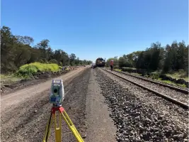

Services
Aerial Mapping
Engineering Surveys
Hydrographic Surveys
Land Development
Mining Surveying
Monitoring Services
Rail Services
Reality Capture
Utility Mapping
Details
- Year established: 1997
Highlights and features
- We have 26 years of experience in Australian geospatial solutions.
- Our team consists of 400+ professional surveyors nationwide.
- We invest in cutting-edge surveying technology and equipment.
- We operate under strict quality standards and Australian regulations.
- Our nationwide presence ensures local expertise with national resources.
What people say
Quality of the data is amazing
Great working with you
Impressed with the quality
Safe and cost-effective solutions
Set new benchmark
Services
Aerial Mapping
Our UAV aerial mapping services utilise drones equipped with LiDAR and high-resolution cameras to capture large-scale survey data. This technology enables efficient topographic mapping, volume calculations, and progress monitoring for infrastructure and mining projects. Our qualified surveyors process this data to create accurate 3D models and orthophotographs, supporting informed decision-making across construction, environmental monitoring, and land development sectors.
Engineering Surveys
We provide precise engineering surveys for civil infrastructure projects including roads, bridges, and railways. Our services cover dimensional control, structural verification, and as-built documentation. Using total stations, GNSS, and laser scanning, we ensure construction projects adhere to design specifications and regulatory standards. Our team supports projects from initial design through to completion, maintaining accuracy within Australian building regulations.
Dilapidation Services
Our dilapidation surveys document building and infrastructure conditions using high-resolution imaging and 3D reality capture. These assessments identify cracks, defects, and structural issues to establish legal records before construction activities. We follow Australian Standard 4349.0-2007, providing defensible reports for residential, commercial, and infrastructure sectors. Our cloud-based data storage ensures long-term accessibility for dispute resolution and compliance purposes.
Land Development
We support land development projects through cadastral surveys, strata subdivisions, and site planning. Our team assists with title creation, boundary determination, and compliance with local government requirements. We provide topographic surveys and development feasibility assessments for residential, commercial, and industrial projects. Our services cover the entire development lifecycle from initial concept to final certification.
Utility Mapping
Our utility mapping services locate and document underground infrastructure using ground-penetrating radar and CCTV inspections. This includes water, sewer, electrical, and gas networks for infrastructure planning and maintenance. We create detailed subsurface records to prevent service strikes during construction projects. Our surveys support asset management and compliance with safety regulations across urban development and industrial sectors.
People
Peter Rullo
Founder
Peter Rullo founded Land Surveys in 1997 after studying surveying at Curtin University. With experience from major projects like Roxby Downs Olympic Dam, he built the company into Australia's leading survey firm. His leadership focuses on innovation, indigenous engagement, and industry partnerships. Peter's vision established Land Surveys' nationwide presence and technological expertise.
Questions
What surveying services does Land Surveys offer?
We provide aerial mapping, engineering surveys, dilapidation assessments, land development, utility mapping, and monitoring services for infrastructure, mining, and construction projects.
Do you operate outside Western Australia?
Yes, we have offices in Perth, Brisbane, Sydney, Melbourne, Darwin, and Papua New Guinea, serving nationwide and international projects.
How do you ensure survey accuracy?
We use calibrated equipment, qualified surveyors, and follow Australian standards while implementing quality assurance processes at every project stage.
Can you handle large infrastructure projects?
Yes, our 400+ team and advanced technology support complex projects like rail networks, mining operations, and major developments nationwide.
What technology do you use?
We utilise UAV LiDAR, terrestrial laser scanning, GNSS, total stations, and cloud-based data management systems for precise geospatial solutions.
How quickly can you complete a dilapidation report?
We generate preliminary reports on-site with final documents typically delivered within one week of assessment, depending on project complexity.
Videos
Reviews (3)
June Wang
Apr 15, 2020
Report
Land measuring instrument manufacturer ,our products covers GIS products, GNSS RTK system for land survey, GNSS receiver for Machine control and Agriculture, GNSS OEM Boards, GNSS Antennas and surveying equipments including Total station, Theodolite and some accessories etc .
Prabhakar Nair
Apr 03, 2020
Report
Amazing trading platform, quick withdrawal I have been using this platform together with the most recommended forex strategy on the internet from Michelle and so far i have no complaints making $7000-$15000 on a weekly basis she is great and i am thankful i was lucky enough to have met her. Contact her email. michellestallon@gmail.com
WhatsApp: +14087154041
WhatsApp: +14087154041
Satyaki Paul
Feb 20, 2020
Report
We required one Senior surveyer two surveyer 400 k/v electric tower survey urgent....plz contact...me Satyaki...9485017870